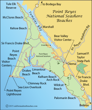
Point Reyes National Seashore Beaches
Marin County

Point Reyes
National Seashore
Location
Sir Francis Drake Blvd. off Highway 1
Approach from Hwy. 1, Sir Francis Drake Blvd., or Point Reyes/Petaluma Rd.
(415) 464-5100 x2
Beach Hours and Fees
Sunrise to midnight, year-round
Entrance fee: Free
Main Attractions
- Rugged coast, beaches
- Hiking, sight-seeing
- Historic buildings
Facilities and Services
- Parking, restrooms
- Picnic area with BBQ grills
- Tomales Point El Reserve
- Visitor Centers
- Lighthouse
- Backcountry Campgrounds
Accessibility
- Visitor Centers
- Parking and restrooms
- Wheelchairs available at visitor centers
- Many trails, some historic buildings, some beaches
- Complete details: Point Reyes Accessibility
Regulations (partial list)
- Alcohol is permitted.
- All natural features are protected; no collecting.
- Fires on beaches allowed with permit from visitor center.
- Fishing is allowed on most beaches and lakes. Check restrictions at Fishing at Point Reyes
- Horses are allowed on most trails. Check limitations at Park Regulations
- Pets on leash are permitted in some areas, but not on most trails. Pets are allowed on Kehoe Beach, Limantour Beach and Point Reyes/Great Beach.
Hazards Include
- Rip currents
- Rough surf and rogue waves (aka sleeper waves)
- Cliffs
- Rising tides
Caution: Check with rangers or lifeguards that conditions are safe for your planned activities.
Webcams
Point Reyes' Most Popular Beaches
With 80 miles of coastline, Point Reyes National Seashore has a number of great beaches. Some are accessible by car or with only short walks, while others require some hiking. With cold water, the danger of rogue or sneaker waves, and hazardous rip-currents, the beaches facing the Pacific deserve extra caution. Beaches in Drakes Bay are sheltered by Point Reyes and they are generally safer for swimming. Even so, caution should be taken.
Drakes Beach
Limantour Beach
Limantour Beach is easily accessed by car. A long, narrow spit of stand stretches out to the mouth of Drakes Estuary. Visitors are rewarded with an abundance of shorebirds and other wildlife. In the spring Gray Whales are often sighted close to shore. Harbor seals are common visitors to the area. Swimming is possible in the chilly water. The beach is favored for picnicking since it is protected from the wind.
Restrooms are available at the beach. Dogs on leash are permitted on the southeast end of the beach. At the other end of the beach the area is protected as a habitat for snowy plover and harbor seals.
Point Reyes Beach - North and South
Also known as The Great Beach, Point Reyes Beach can be accessed by car in two places off Sir Francis Drake Boulevard. The immense beach extends for 11 miles along the Pacific Ocean side of Point Reyes National Seashore. Huge waves crash ashore all along Point Reyes Beach. Rogue waves, or sneaker waves as they are often called, are a particular hazard. Visitors are cautioned to always keep an eye on the ocean and to stay well back from the surf. Swimming and wading are not recommended.
Walking the beach, photography, wildlife viewing, and picnicking are favorite activities on these beaches. Restrooms are available at both the north and the south parking areas. Dogs on leash are permitted on the beach, but not north of the north entrance. During the winter elephant seals come ashore south of the south beach access. At those times people and dogs are restricted from that area.
Drakes Beach
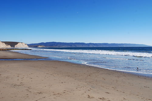
With parking close to the beach and amenities such as a visitor center, a cafe, restrooms, and outdoor showers, Drakes Beach is one of the most popular in the park. Cliffs of white sandstone rise behind the beach. Sand stretches away in either direction from the parking lot. A picnic area makes a good place for an outdoor meal.
Beaches Accessed Only by Trail
Point Reyes is crisscrossed by trails, too many to be displayed on our map. Most of the beaches in the southern part of the National Seashore are only accessible on foot or by boat. Some offer overnight camping.
McClures Beach
Tucked up against the cliffs at the northern end of the National Seashore, McClures Beach usually thrills visitors with its huge, crashing waves. A short, steep hike leads to the beach. Although the rocky coast here is tempting to explore, it is fraught with danger. Rogue waves and rising tides can suddenly engulf a rock that had appeared to be out of reach of the surf.
Sculptured Beach
Sculptured rocks along the shore give the beach its name. Visitors must make a 2 mile stroll from Limantour Beach or Laguna Ranch to reach Sculptured Beach. During the winter when streams are flowing, water crosses the sand in a couple of places, making for wet fords for those coming along the beach. Look for sea caves and sea stacks. Low tide is the best time to visit the beach both for the rocks and for tide pools.
Kelham Beach
Located north of Arch Rock, Kelham Beach is a 4.8-mile hike from its Bear Valley trailhead. The arch is at the south end of the beach. To the north is an arched tunnel that leads to what is called Real Secret Beach. Real Secret Beach is hidden when the tide comes in, so visitors should use caution.
Kehoe Beach
From the trailhead the hike to Kehoe Beach is only 0.6 miles along a trail that passes a marsh and crosses sand dunes. Geology buffs turn to the north to explore the interesting rocks and faults. Dogs on leash are allowed on the north part of the beach. To the south is a stream. No dogs are allowed here because it is a snowy plover nesting area.
Wildcat Beach
Wildcat Beach at the southern end of the National Seashore is one of the most remote beaches in the park. Hikers usually start out at the Palomarin trailhead and head north 5½ miles, although there are several other longer access trails, The highlight of Wildcat Beach is Alamere Falls cascading down the cliff near Double Point.
Palomarin Beach
The most southern of the National Seashore's beaches is Palomarin beach, accessed by a road from Bolinas and then a steep trail down the cliff. Visitors to the beach usually arrive at low tide so they can explore the tide pools.
Nearby Beaches
Books and Maps of Local Interest
Ocean Safety
California State Parks and Recreation cautions that "large surf, cold water temperatures, backwash, sudden drop-offs,
pounding shorebreak, and dangerous rip currents can turn what seem like safe activities such as
playing near the surf line, wading, or climbing on rock outcroppings, deadly."
Learn more about ocean safety at
CA State Parks: Ocean Safety
California's Best Beaches
Every effort is made to provide accurate and up to date information, but we cannot be responsible for errors or for changes that may have occurred since publication. Always confirm information with the service provider and check for any recent changes that may have been made. Also, check with lifeguards that conditions at the beach are safe for your planned activities.
The map displayed above is for illustrative purposes only. California's Best Beaches website makes no warranties regarding the accuracy, completeness, reliability or suitability of any of its maps. The information provided on this website is done so without warranty of any kind, either expressed or implied, including but not limited to, the implied warranties of merchantability and fitness for a particular purpose.