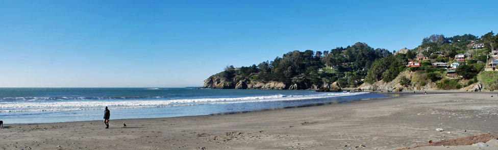
Muir Beach

Marin County

Muir  Beach, Marin County, California

Muir Beach

Marin County


Muir Beach

Muir Beach is a favorite with locals from Marin County and San Francisco. Only a 35-minute drive from San Francisco, the beach is close enough to make even a couple of hours of time on the pristine sand worth the drive. The beach was known as Big Lagoon Beach until the late 1930s.

In 2013 Muir Beach went through a 5-month renovation. Among the upgrades at the beach were a new parking lot, restoration of damaged wetlands, a new bridge spanning Redwood Creek, new trails, and new restrooms.
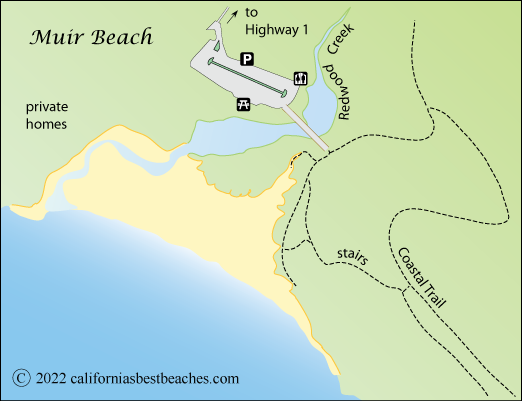


map of Muir Beach, Marin County, CA

Redwood Creek

Redwood Creek has its headwaters on Mount Tamalpais and flows through Muir Woods and down the Frank Valley before reaching the sea at Muir Beach. The stream has long been a spawning area for steelhead trout and salmon. When the number of salmon in the stream fell off, park naturalists initiated a plan to improve the stream's ecosystem, including restoration of its floodplain.

Wildlife sightings in the area of Muir Beach and up toward Muir Woods have been plentiful. Several species of owls have been seen in the area, including spotted owls and burrowing owls. On the ridges above the beach visitors have seen bobcats, coyotes, gray foxes and golden eagles.
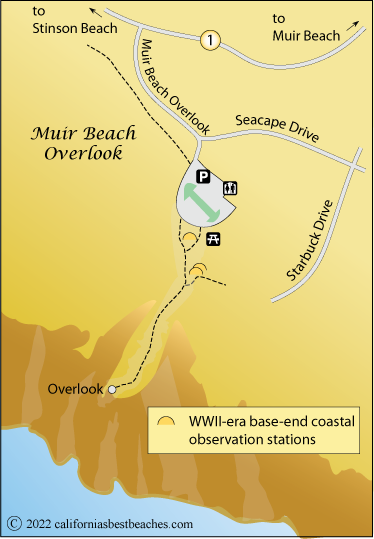
Muir Beach Overlook

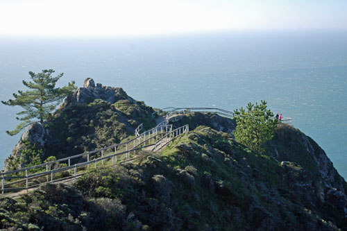
Located one half mile north of Muir Beach, the Muir Beach Overlook provides spectacular views of the Pacific coast and on clear days as far south as San Francisco. Whale watchers know this is a great location from which to spot migrating whales during the winter months.

Muir Beach Overlook, CA

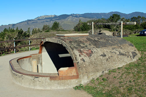
Base-end stations used by soldiers to track the progress of ships during World War II are situated on the hillside overlooking the ocean. Information from the stations was relayed to shore artillery units defending the coast against invasion. With the invention of radar, the stations became obsolete. Today visitors can explore the stations.

Base-end observation station AT Muir Beach Overlook, CA

Parking is available it a lot just off Highway 1. At the parking lot are portable toilets and a small picnic area. The picnic site has the reputation of being rather windy. A trail with railings on either side leads out and down the spine of the ridge to the observation point. The path includes a few stairs along the way. Steep cliffs drop away on either side of the trail.

map of Muir Beach Overlook, Marin County, CA


Coastal Trail

The Coastal Trail passes through Muir Beach, giving hikers an opportunity to set out either to the north or south. To the south the trail climbs to the slopes overlooking the ocean and winds its way 3.7 miles south to Tennessee Valley and Tennessee Cove. To the north the trail leads into Muir Woods and Mt. Tamalpais.

Read more about the many hiking opportunities in the area on the ACTIVITIES page.


Nearby Beaches

Red Rock Beach

Red Rock Beach, located south of Stinson Beach, is known as a popular nude beach and also as a great place for rock climbers to practice bouldering. Rock climbers know the beach as Mickey's. The beach has a reputation for its friendly atmosphere. The sand on the quarter-mile-long beach is sometimes swept away by the wave action in the winter, only to return by spring.

There is parking on either side of Highway 1 north of the road to Steep Racine Environmental Camp. A steep, winding trail down to the beach. Red Rock Beach has no facilities.

Tennessee Cove

Tennessee Cove is along the Marin Headlands off Highway 1 at the end of Tennessee Valley Road. Visitors park and then hike 1.7 miles to the black-sand beach. Tennessee Cove and valley were named for the SS Tennessee which sank just offshore in 1853. A famous rock arch which once stood in Tennessee Cove collapsed in December 2012. Restrooms are available in the parking lot. Dogs are not allowed on the beach.

Rodeo Beach

Rodeo Beach is the largest and most accessible of the Marin Headlands' beaches. Two military forts were located here - Fort Cronkhite and Fort Barry. The old structures are now used by the park service. The beach faces the Pacific Ocean and is strewn with colored pebbles. Kite flyers find plenty of wind. Restrooms, outdoor showers, and picnic tables are available. Inland from the beach is Rodeo Lagoon.

Kirby Cove

Kirby Cove along the Marin Headlands near the northern terminus of the Golden Gate Bridge. The small beach is accessed by a 1-mile hike down a dirt road from a parking area along Conzelman Road. A free parking lot is near a dirt road that leads to the beach. Restrooms and picnic tables are available there. Visitors enjoy great views of the bridge, a sea cave, and a small sandy beach. Expect to find some nude sun bathers. Camping is allowed there with reservations.

Webcams

Muir Beach Webcam


  TOP


Ocean Safety

California State Parks and Recreation cautions that "large surf, cold water temperatures, backwash, sudden drop-offs, pounding shorebreak, and dangerous rip currents can turn what seem like safe activities such as playing near the surf line, wading, or climbing on rock outcroppings, deadly." Learn more about ocean safety at CA State Parks: Ocean Safety