Guadalupe Dunes and Beach

Santa Barbara County

ocean waves, Santa Barbara County, California

Guadalupe Dunes and Beach

Santa Barbara County


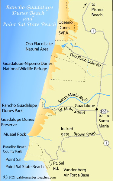
Rancho Guadalupe Beach and Dunes

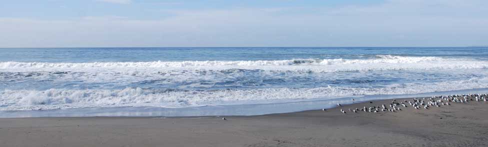
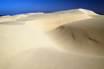
Rancho Guadalupe Beach and the adjoining Guadalupe Dunes Preserve extend south along 3 miles of coastline from the Santa Maria River to Mussel Rock. The dunes soar to an amazing 500 feet in places, making them the highest sand dunes along the coast.

To the north is the Guadalupe-Nipomo Dunes National Wildlife Refuge, protected as a nesting place for the endangered Snowy Plover during part of the year. The wildlife refuge has 1.8 miles of ocean front. More than a hundred species of rare plants and animals are found in the refuge.

The entire dunes complex spreads for 18 miles along the coast. The northern parts are included in the Oceano State Vehicular Recreation Area.


map of Gaviota State Park, Santa Barbara County, CA

The dunes were the location for the filming of part of Cecil B. DeMille's classic 10 Commandments.

sand dunes near Guadalupe Beach, CA

Guadalupe-Nipomo Dunes National Wildlife Refuge

The Guadalupe-Nipomo Dunes National Wildlife Refuge was established to protect breeding habitat for the endangered California least tern and the threatened western snowy plover. Other endangered species found in the refuge include the California tiger salamander, the California red-legged frog, Morro blue butterfly, shoulder band dune snail, and 16 rare or endangered plant species. Other animals found in the refuge are mountain lions, bobcats, mule deer, and a wide variety of birds.

Access the refuge near Oso Flaco Lake via Oso Flaco Lake Road or on West Main Street out of Guadalupe. The refuge is administered by Hopper Mountain National Wildlife Refuge Complex in Ventura, California.

The Guadalupe-Nipomo Dunes Interpretive Center had information about the dunes and other points of interest in the area. They are located at 1065 Guadalupe Street in Guadalupe. They are open Saturdays and Sundays from 10:00 AM to 4:00 PM.


Point Sal State Beach

Remote and rugged Point Sal State Beach south of Mussel Rock sees few visitors because access is only available by hiking a 6-mile road that passes through Vandenberg Air Force Base. The beach is managed by Santa Barbara County Parks. With no overnight stays allowed, visitors must plan their trips to Point Sal State Beach so that they are back at the trailhead by sunset. Those who make the trip are rewarded with beautiful vistas of the coast and a secluded sandy beach. There are no facilities at the beach.

Point Sal Road once ran to the beach, but sections of it washed out in recent years and have not been repaired for vehicular traffic. Conditions may change along the route and it is wise to call the park before your visit.


Directions to Point Sal State Beach

From Highway 1 south of Guadalupe, turn west onto Brown Road and follow it for about 4 miles to the locked gate. Park along the side of the road, step through a pedestrian passage-way and follow the road, after about 6 miles connecting to Point Sal Road. Your route climbs 800 feet to Point Sal Ridge and then descends about 1200 feet to the beach. It is a significant climb back up to the top of the ridge on your return trip. Carry plenty of water. Expect little shade.

Part of the road passes through Vandenberg Air Force Base. The road is closed from time to time during missile launches, so - once again - it is advisable to check with the park before starting your hike. Bicycles and horses are not allowed. Also, no photography is permitted on base property, and you may encounter military police patrolling the area. Photography is allowed once you reach the beach.

Paradise Beach

The area around Paradise Beach north of Sal Point is jointly owned by Santa Barbara County, the state of California, and the US Bureau of Land Management. Combined, the property covers about 560 acres. Efforts are underway to add additional land and create an 800-acre Point Sal Reserve.

  TOP


Ocean Safety

California State Parks and Recreation cautions that "large surf, cold water temperatures, backwash, sudden drop-offs, pounding shorebreak, and dangerous rip currents can turn what seem like safe activities such as playing near the surf line, wading, or climbing on rock outcroppings, deadly." Learn more about ocean safety at CA State Parks: Ocean Safety