Palos Verdes Peninsula Beaches
Malaga Cove
Malaga Cove is immediately south of Torrance County Beach. Several surfing spots are popular here, including RAT Beach (Right After Torrance) and Haggerty's. Divers like the area. The sand and rock beach makes a good place for exploring. There are outdoor showers, but no restrooms. Tide pools are found at the south end. a partially paved road leads from the parking lot down to the beach. Other steep paths can be found.
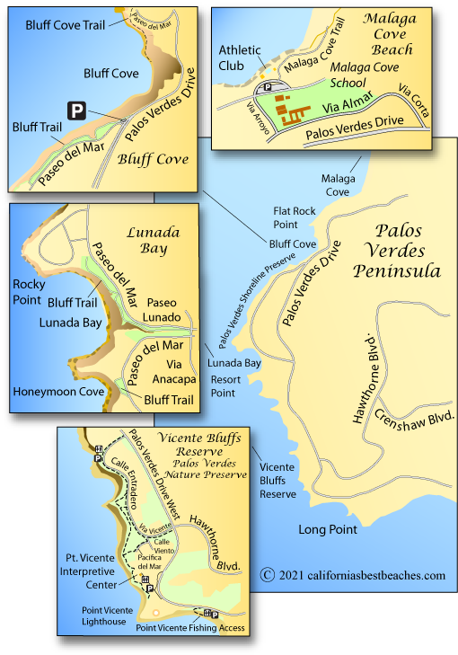
Palos Verdes Estates Shoreline Preserve
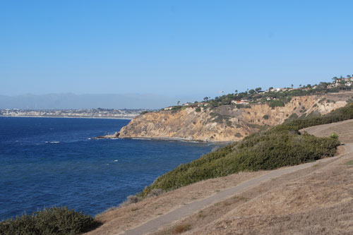
The 130-acre Shoreline Preserve extends 4½ miles along the Pacific coast from Malaga Cove to just south of Resort Point. This undeveloped park has numerous trails that wind along the bluff overlooking the ocean. In some places steep and hazardous trails lead down to the rocky coast.
The shore is most popular with divers and surfers. Tide pools along the base of the bluffs make interesting places to investigate. As a marine preserve, nothing can be disturbed or removed, including shells. The shore is a wintering area for shorebirds such as willets, marbled godwits, and plovers.
Bluff Cove
One of the most popular spots along the Shoreline Preserve is Bluff Cove. Visitors will find overlooks with views of the shore, ocean, and distant islands. A bluff trail provides a short tour of the area. At nearby Flat Rock Point a path leads down to Bluff Cove. Parking is available in a small parking lot at Paseo del Mar and Palos Verdes Drive West and also along the streets.
Several city-owned homes above Bluff Cove are slated to be demolished in 2013 due to landslide danger. The land will be left vacant as part of the preserve.
Lunada Bay
The point north of Lunada Bay is one of the top surfing spots along the coast. In the winter the surf can rival many of the more famous spots in California and Hawaii. Stories of fierce localism abound. Sections of bluff-top trails give visitors a scenic path to follow and overlook the ocean. A few steep, hazardous trails lead down to the shore, but they are not recommended.
Other Palos Verdes Peninsula
Beaches and Overlooks
Frank A. Vanderlip, Sr. Park
Location: 6500 Seacove Drive
Rancho Palos Verdes
Features: This half-acre, bluff-top park provides benches overlooking the ocean. There
is a short path and a safety fence at the edge of the cliff. No other facilities are available nor is there
beach access. The park is open from dawn to dusk.
Abalone Cove Shoreline Park
Notice: "As of July 9, 2024, Abalone Cove Beach, Sacred Cove Beach, and all beach access trails in the Abalone Cove Reserve are closed to the public until further notice due to impacts of accelerated land movement in the Portuguese Bend Landslide complex."
Location: 5970 Palos Verdes Drive South, Rancho Palos Verdes
Hours: Summer and weekends year-round 9:00 AM to 4:00 PM, off-season weekdays noon to 4:00 PM
Fees: $5 per car, seniors free during off-season
Features: Two beaches - Abalone Cove and Sacred Cove - are the areas main attractions, although
the bluff-top park area sees plenty of use. Trails, picnic areas, and restrooms are found along the bluff.
For a map and complete information, see our page
ABALONE COVE.
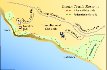
Ocean Trails Reserve
Location: 6500 Seacove Drive
Rancho Palos Verdes
Features: This half-acre, bluff-top park provides benches overlooking the ocean. There
is a short path and a safety fence at the edge of the cliff. No other facilities are available nor is there
beach access. The park is open from dawn to dusk.